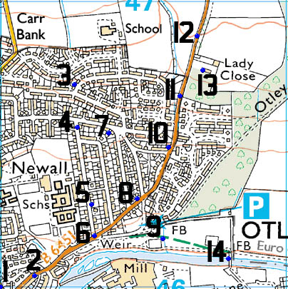
The Ordnance Survey list has 14 Benchmarks in grid SE2046, most of which are normal Cut Marks, but there are a couple rivets as well. The square does cover my house and is the centre of the grid squares I am looking at
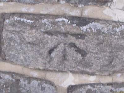
1 – CUT MARK – WALL 3.3M NW WALL JUNC NE SIDE BILLAM’S HILL SW FACE
FOUND IN GOOD CONDITION
The Cut Mark is on the wall on the North East side of Billams Hill, on the South West face, 3.3mtrs north west of the wall junction
I was expecting this mark to have gone missing as the wall has been rebuilt in places and repointed all over – and there is now a housing estate behind it not the grounds of Newall Hall, but it’s still there
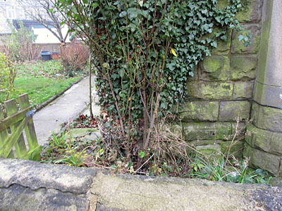
2 – CUT MARK – NO 22 FARNLEY LANE NW FACE N ANG
EXISTENCE NOT CONFIRMED
The Cut mark is on the North West face of No-22 Farnley Lane, at the north corner.
That makes it somewhere behind all the creeper stems, I would assume it’s still there, but it’s not visible
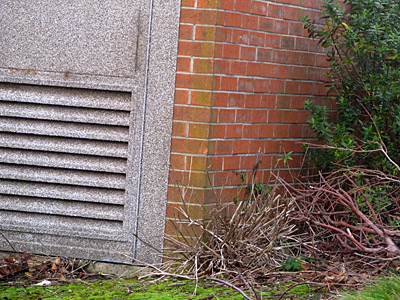
3 – CUT MARK – NBM EL SUB STA SE FACE E ANG
MISSING
The Cut Mark is on the South East face of the Substation, on the East corner
The Substation has been renovated since the last surveying was done (in 1975) and the cut mark lost
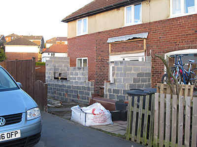
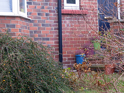
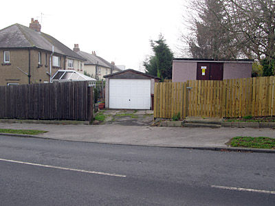
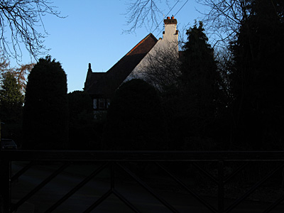
4 – CUT MARK – NO 79 THE CROSSWAY N FACE NW ANG
MISSING
The Cut Mark is on the North Face of 79 The Crossways, on the North West corner
Except that as you can see in the photograph the house has been extended to the North, thus the mark is lost
5 – CUT MARK – NO7 PRINCE HENRY RD S FACE 1.2M SW ANG
FOUND IN GOOD CONDITION
The Cut Mark is on the South face of 7 Prince Henrys Road, 1.2mtrs along from the South West corner
You have to peer round the hedge a bit, but the mark is clear enough to see
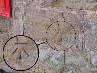
6 – CUT MARK – WALL NE SIDE JUNC FARNLEY LANE PRINCE HENRY ROAD
FOUND IN POOR CONDITION
The Cut mark is on the Wall at the North East side of the junction of Farnley Lane and Prince Henry Road
You can just about make out the mark still, to the right of the Post Box – I have tried to highlight it in the photo

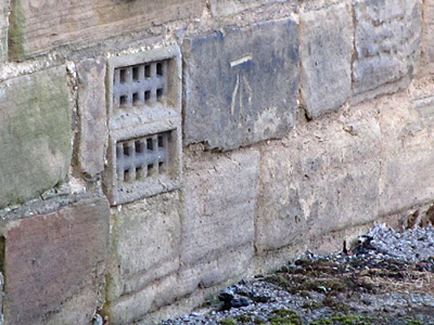
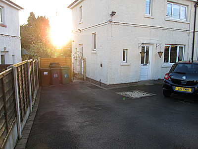
7 – CUT MARK – NO99 THE CROSSWAY S ANG SE FACE
EXISTENCE NOT CONFIRMED
The Cut Mark is on the South Face of 99 The Crossways, on the South East corner
It’s a private house and the details lead you to the back of the house behind the gate.
8 – CUT MARK – NO48 FARNLEY LANE S ANG SE FACE
MISSING
The Cut mark is on the South East face of No.48 Farnley Lane, on the South Corner
The alterations and extension to the house on this corner seem to have wiped out this mark
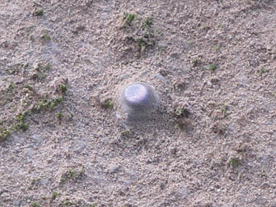
9 – RIVET – NBM RIVET CUL S SIDE PATH W SIDE STR
FOUND IN GOOD CONDITION
The rivet is on the South side of the path over the culvert on the West side of the stream
I thought this one might have gone missing as the bridge over the stream has been rennovated and the paths relaid, but the old walls around the culvert were kept and the rivet still is in place
10 – CUT MARK – GTP 2.8M SW FENCE JUNC NW SIDE FARNLEY LANE
MISSING
The Cut mark is on a gatepost on the North West side of Farnley Lane, 2.8mtrs south west of the fence junction
The fences here have all been replaced fairly recently and all the old gateposts removed
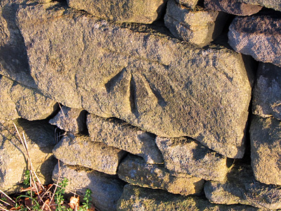
11 – CUT MARK – STO P 9.5M NE FENCE JUNC SE SIDE FARNLEY LANE
FOUND IN GOOD CONDITION
The Cut Mark is on a Stone Post 9.5mtrs North East of the fence junction on the South East side of Farnley Lane
It looks like the stone post is actually an old gatepost that was incorporated into the wall when it was extended at some time. This post had been covered with ivy and then a bush in front of it, but it had been uncovered by someone else a few days before I photographed it (a photograph of it had appeared on an Otley facebook site so I knew it had been cleared)
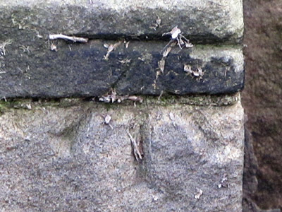
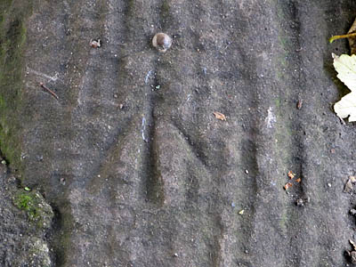
12 – CUT MARK – WALL 64.2M SW PRODN FENCE SE SIDE FARNLEY LANE
FOUND IN GOOD CONDITION
The Cut Mark is in the wall 64.2mtrs South West of a point where the field boundary fence would meet the wall if it went that far (which it doesn’t !) on the South East side of Farnley Lane.
A nice clear mark on a large wall stone, the wall has been damaged and rebuilt in many places but not here
13 – CUT MARK – LADY CLOSE NW ANG PORCH W FACE
EXISTENCE NOT CONFIRMED
The Cut Mark is on the West Face of Lady Close, on the North West corner of the porch
Lady Close is a private house and the gardens prevnt you from seeing the location from the road
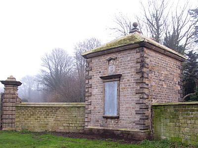
14 – RIVET – NBM RIVET CONCRETE BUTT W SIDE FB N SIDE R WHARFE
FOUND IN GOOD CONDITION
The Rivet is in the concete buttress on the West side of the footbridge over the River Wharfe, on the North bank
The footbridge is actually a disguised support for a 3ft diameter sewage pipe that runs across the river here to the old sewage plant (now a Nature Reserve) and dates from about 1960. If I hadn’t seen rivets like this while looking for the Ye Ole Survey Monument geocache I would not have known what to look for and marked it as missing, but a kick off of the moss and there it was
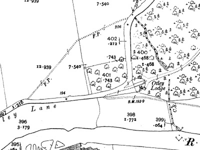
OLD MARKS
There are more Survey marks than those shown on the OS list, most of these are older survey marks that have been lost over time, but some of these are still visible if you look carefully.
Farnley Lane used to run up to the Lodge Gates of Farnley Hall then turn sharp left up what is now a footpath back to where the current road goes (in a coincidental twist the current road follows what was a footpath prior to the alterations). The old Maps show a benchmark on the South West corner of the South Lodge, and this is still clearly visible today